Relief maps
This product allows you to get relief maps around the world. Set the position of the sun in parameters and you will receive accurate illumination of the earth’s surface and its relief for these conditions.
You can use Relief maps as a base layer in your maps. Also, you can use Relief maps with our Weather map layers.
This product is a combination of a layer tint (colored raster) and a hillshade.
URL format and Parameters to get Relief maps
Use the following URL format and parameters to get Relief maps. Please pay attention on URL example.URL format
http://maps.openweathermap.org/maps/2.0/relief/{z}/{x}/{y}
| Parameters | ||
|---|---|---|
z |
required | Number of zoom level |
x |
required | Number of x tile coordinate |
y |
required | Number of y tile coordinate |
appid |
required | Your unique API key (you can always find it on your account page under the "API key" tab) |
| Optional parameters to configure the layer tint | ||
|---|---|---|
opacity |
optional | Degree of relief maps opacity (layer tint and hillshade). Available value from 0 (transparent) to 1 (nontransparent). Default value - 0.8 |
palette |
optional | Color palette. You can use custom palettes for each layer. You can also create a palette for yourself and pass it to the URL as follows {value}:{HEX color};..;{value}:{HEX color}. More information about it here. |
fill_bound |
optional | true or false. If true, then all values outside the
specified set of palette values will be filled by color corresponding to the nearest specified
value. Default value - false: all values outside the specified set of palette values
are not filled. |
mk_empty |
optional | true or false. If true, then all areas for which there is
no relief data (for example, oceans) will be filled with the default color. If false,
then all areas for which there is no data will be filled with empty tiles. Default value - true
|
| Optional parameters to configure the hillshade | ||
|---|---|---|
sun_az |
optional | Azimuth angle of the light source. Degrees, 0° - West, 90° - South, 180° - East, 270° - North. Default value - 315 |
sun_el |
optional | Altitude angle of the light source above the horizon. Degrees, 90° - Solar zenith. Default value - 45 |
zfactor |
optional | The ratio of spatial coordinates (x, y) to height units (z).
The zfactor allows adjusting the units of measure for the (z) units when they are different from the (x,y) units of the input surface. The z-values of the input surface are multiplied by the zfactor when calculating the final output surface. Default value - 0.025 |
mix_w |
optional | Degree of layer tint and hillshade opacity. Available value from 0 to 1. If mix_w=0, then layer tint - transparent, hillshade - nontransparent. If mix_w=1, then layer tint - transparent and hillshade - nontransparent. Default value - 0.25 |
URL example
http://maps.openweathermap.org/maps/2.0/relief/{z}/{x}/{y}?appid={API key}
For example, Leaflet, OpenLayers. You can also use any other apps that support the display of layers. Learn more
How to pass my palette in Relief maps?
We have custom palettes, but you can use your own palette and pass it to the URL as shown {value}:{HEX color};..;{value}:{HEX color}.
The number of values in the custom palette can be any, but not less than 2. You can set the color for any value with any precision.
To pass the code of color, use the HEX format.
URL example
http://maps.openweathermap.org/maps/2.0/relief/{z}/{x}/{y}?palette=0:FF0000;1000:00FF00;3000:0000FF&appid={API key}
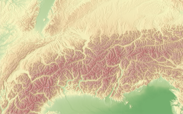
Examples of Relief maps
Layer tint + Hillshade
mix_w : 0.25
fill_bound : false
sun_az : 315
sun_el : 45
Default parameters
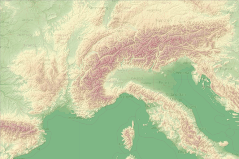
URL example
http://maps.openweathermap.org/maps/2.0/relief/{z}/{x}/{y}?appid={API key}
Layer tint
mix_w : 0
fill_bound : false
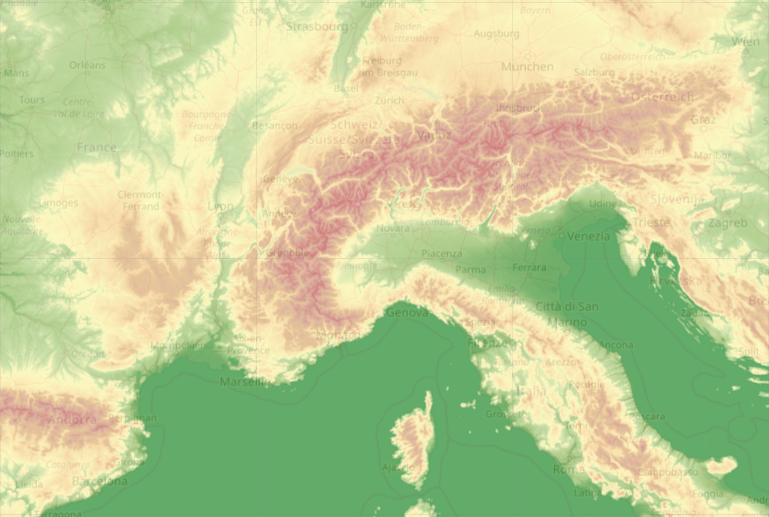
URL example
http://maps.openweathermap.org/maps/2.0/relief/{z}/{x}/{y}?mix_w=0&appid={API key}
Hillshade
mix_w : 1
fill_bound : false
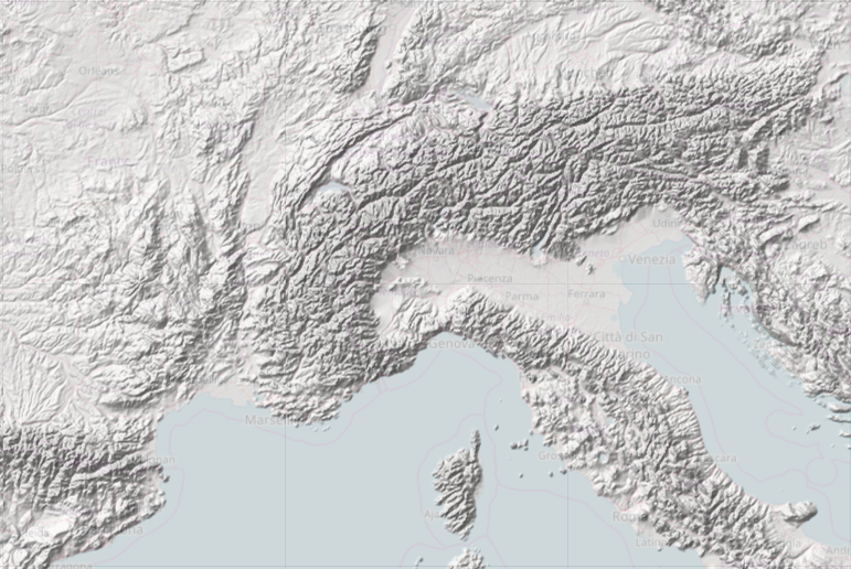
URL example
http://maps.openweathermap.org/maps/2.0/relief/{z}/{x}/{y}?mix_w=1&appid={API key}
Custom illumination 1
sun_az : 180
sun_el : 135
opacity : 1
fill_bound : false
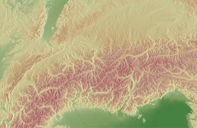
URL example
http://maps.openweathermap.org/maps/2.0/relief/{z}/{x}/{y}?sun_az=180&sun_el=135&
opacity=1&appid={API key}
Custom illumination 2
sun_az : 0
sun_el : 45
opacity : 1
fill_bound : false
URL example
http://maps.openweathermap.org/maps/2.0/relief/{z}/{x}/{y}?sun_az=0&sun_el=45&
opacity=1&appid={API key}
Libraries to connect Relief maps
Open Layers
- Classes of weather layer and weather stations layer
- Possibility to set your own style
- Classes with clustered markers
- Support of marker server clustering
Leaflet
- Embedding of layer with current weather in cities
- Embedding of layer with weather stations
- The library supports customer clustering
Leaflet library
Another implementation of map based on Leaflet technology supports OWM's TileLayers and current city/station data. It is configurable with many options. For current city/station data the library supports refreshing the data in intervals, some types of client-side clustering (show only the station/city with the highest rank for a defined pixel square), custom image set (if you provide one), different languages ("en", "de", "ru", "fr", but translation is incomplete), minZoom and others.
Source and documentation (README.md) is available on GitHub https://github.com/buche/leaflet-openweathermap
Example of weather map: https://github.com/owm-inc/VANE-intro/tree/master/apps