Frequently Asked Questions
General overview
About the company: what is OpenWeather?
OpenWeather (headquartered in London) is a team of IT-intellectuals that create pivotal products for business using climate data. For each point on the globe, OpenWeather provides hyperlocal minutely forecast, historical data, current state, and from short-term to annual forecasted weather data. All data is available via industry standard APIs.
OpenWeather Ltd. has more than 6 million users including Fortune 500 companies and thousands of other businesses globally.
How accurate is OpenWeather?
OpenWeather hyperlocal ML-powered weather model inaccuracy is less than 1% (it is a % of the
time when the model was >5°C of ground truth, lower is better).
You can find out more about the OpenWeather model here.
Is OpenWeather API free?
We offer a Free rate that grants access to a variety of data types, including current weather, forecasts, and weather maps, etc. Upon registration on our website using just your email (no banking details required), you will receive an API key that allows for 60 free calls per minute.
Additionally, you can access our One Call API 3.0, which offers an extended data collection. This includes the current weather, a range of forecasts from minute-by-minute predictions for the upcoming hour to long-term forecasts spanning 1.5 years, a historical archive going back over 47+ years and many more. With a subscription to One Call API 3.0, you only pay for the number of API calls made to this product, and you receive 1,000 API calls per day for free.
Which weather data OpenWeather provides?
OpenWeather provides forecasts, current weather and historical data for 47+ years back. Forecasts have different granularity and horizon - from minute by minute, hourly and daily forecasts from . Amongst our products are: One Call API 3.0, Solar Irradiance & Energy Prediction service, Road Risk API, Air Pollution API and solutions for advanced weather parameters like solar irradiance data, UVI, dew point, government weather alerts, etc. Please review our product list page and find more info in the product documentation.
Where does OpenWeather get data from?
To offer global coverage and account for local nuances of climate, OpenWeather hyperlocal
ML-powered weather model processes a number of datasets of different granularity, such as
local and global models from national agencies such as NOAA and MetOffice, and enhances its
model with data from radars, weather stations and satellites.
You can find out more about the OpenWeather model here.
Get started
How to get an API key
In order to use our services, you need to get and use your personal API key in all your API requests. How to do it:
- Sign up and get an API key (APPID) on your account page.
- Verify your email address via a confirmation letter that will be sent to you. 1 hour after registering, it is possible to resend the confirmation yourself in the profile settings.
- After verification, check your Inbox again to find our welcome email that contains your API key and important information.
Congratulations! Now you have a Free OpenWeather account and can start using our services. We highly recommend you to read the API documentation that explains how to use our APIs.
What products and types of data can I request?
For each point on the globe, OpenWeather provides hyperlocal minutely forecast, historical data, current state, and from short-term to annual and forecasted weather data. All data is available via industry standard APIs.
One Call API by call:
Make just one API call and get all your essential weather data for a specific location with One Call API 3.0.
- Current weather
- Minute forecast for 1 hour
- Hourly forecast for 48 hours
- Daily forecast for 8 days
- National weather alerts
- Weather data for 47+ years history archive and 4 days ahead forecast by timestamp
- Daily aggregated weather data for 47+ years historical archive and 1,5 year forecast ahead
- Weather overview with a human-readable weather summary for today and tomorrow's forecast, utilizing OpenWeather AI technologies.
- AI Weather Assistant for retrieving weather data and weather-related advice in a human-readable and friendly format
For more functionality, please consider our generous professional subscriptions.
Professional collections:
Current Weather and Forecasts Collection
How to get:
- APIs (you can request data for geographic coordinates, ZIP codes, city name, city ID, number of cities)
- Bulk Download (download already collected and regularly updated data for a list of global locations; available for premium subscriptions)
How to get:
- On-the-fly bulks for customised lists of coordinates
- Marketplace of prepared data sets (coordinates, cities, zip codes) - History Bulk (47+ years back), History Forecast Bulk (from 7 Oct 2017)
- APIs to a timestamp / a period (subscriptions with different limits on calls and depth of archive)
- Solar Irradiance API
- Solar Panels Energy Prediction
- Global Weather Alerts
- Road Risk API
- Global Precipitation Maps - Forecast and historical data
- Weather Maps 2.0 with 1-hour step
Detailed information about all our products can be found on the Pricing page.
Do I need to activate my API key?
Your API key will be activated automatically, up to 2 hours after your successful registration. We invite you to read the API documentation that explains how to use our APIs.
How can I use an API key in API calls?
To authorise a request from you and process it, we require you to use your unique API key in each API call.
In order to do this, add your API key as an appid parameter to the GET request, like in the following example:
api.openweathermap.org/data/2.5/weather?id=524901&appid=YOUR_API_KEY
Just use your API key instead of “YOUR_API_KEY” with your personal API key, it can be found in your personal account on the “API keys” page. You can also create additional API keys there.
Where can I find my API key(s) and generate additional ones?
Your API key can be found in your personal account on the “API keys” page. You can always create additional API keys there.
How many keys can I create?
You can create as many keys as you like. The total number of API calls for your account is counted based on all of your API keys together - please note this when choosing a subscription as they have various limits on API calls that can be made per day/per minute.
How to delete an API key?
You can delete unnecessary API keys but please note that your account with us should have at least 1 API key at any time.
To find your API key, go to your personal account and click the “API keys” tab
When you have more than 1 registered API key, there will be an option to delete an API key.
How often is the weather data updated?
Our Open Weather model is updated every 10 minutes and provides data on all essential weather parameters such as temperature, precipitation, wind, pressure and others. You can find out more about the OpenWeather model here.
License
Can I use OpenWeather’s APIs commercially?
Yes, you can. Please see our pricing page for more details.
How to ensure that I give the attribution to OpenWeather correctly?
For the plans between Free and Professional, the attribution requirement is obligatory. When it is required by your license you should place the following information in the visible part of your solution:
- ‘Weather data provided by OpenWeather’
- Hyperlink to our website https://openweathermap.org/
- OpenWeather logo. We provide a library of different styles to match your application design. You can download them here.
If you have any doubts about your specific scenario, please reach out to our support team and we will be glad to advise.
Technologies
What models do you use?
OpenWeather provides accurate weather data by drawing on trusted sources such as weather stations, satellites, radar systems, and advanced models like GFS, ECMWF, and its own OWHL™️. These partnerships with the UK Met Office and other national meteorological agencies boost reliability, with updates released every 10 minutes to ensure precision. Remarkably, the OWHL™️ model reports less than 1% of temperature predictions deviating by more than 5°C. Widely recognised as a leading provider of short-term forecasts, OpenWeather acknowledges that accuracy diminishes over longer periods due to atmospheric complexity. Thus, while short-term forecasts remain highly reliable, it is prudent to view predictions beyond a week with a degree of caution.
Continuously refining its models using real-time data, OpenWeather delivers reliable forecasts worldwide, covering both remote and densely populated areas. It also offers minute-by-minute precipitation data and hyperlocal insights, establishing itself as a trusted choice for businesses across the globe. You can find out more about OpenWeather model here.
I have a weather station. Can I connect my station with your system?
If you also believe in the significance of climate data in tackling climate and healthcare challenges and would like to contribute to our initiatives, then we invite you to connect your automated weather station to our platform. The accuracy of weather data benefits from enthusiasts from all over the world and we reward these contributions with our Startup plan.
To contribure your data to our system, please use the Weather station API. To get access to the Startup plan, please contact us.
APIs
What are the minimum/maximum temperature fields in the Current Weather API and Forecast Weather API?
In the Current Weather API and Hourly Forecast API:
As it is a current weather data that reflect weather conditions only for the current
moment, we add optional statistical parameters the temp_min and
temp_max fields to show dispersion of temperature at this current moment.
This is the minimum/maximum currently observed temperature or forecast temperature
(within large megalopolises and urban areas).
In the 16-Day Forecast API and 30-Day Forecast
The list.temp.min and list.temp.max fields are minimum/maximum
daily temperature, and show the minimum and maximum temperatures in the day.
Which time format and timezone are used?
OpenWeather uses Unix time and the UTC/GMT time zone for all API calls, including current
weather, forecast and historical weather data. The timezone_offset
parameter shows the shift in seconds from UTC. In a One Call
API response, there is also a timezone parameter that shows the time zone name
for the requested location.
Why I do not see some parameters in the API response?
If you do not see some of the parameters in your API response, it means that these weather phenomena just have not happened for the selected location at the time of measurement. Only actually measured or calculated data is displayed in an API response.
What is the format of the API response?
The JSON format is used by default. To get data in the XML or HTML format, just use “xml”
or “html” for the mode parameter. The HTML format is available for Current Weather API only. For the One
Call API, data is only available in the JSON
format. If the mode parameter is omitted, the format is JSON by default.
Examples of API calls:
- JSON:
api.openweathermap.org/data/2.5/weather?q=London&{YOUR_API_KEY} - XML:
api.openweathermap.org/data/2.5/weather?q=London&mode=xml&{YOUR_API_KEY} - HTML:
api.openweathermap.org/data/2.5/weather?q=London&mode=html&{YOUR_API_KEY}
How can I switch between temperature units in API calls?
Temperature is available in Fahrenheit, Celsius and Kelvin units. Kelvin is used by default, with no need to use the units parameter in API calls.
For temperature in Fahrenheit, use "units=imperial".
For temperature in Celsius, use "units=metric".
You can find examples of API calls in the documentation for the service you are interested in.
A full list of all API parameters, with units, can be found here.
What are the weather condition codes and icons?
A list of weather condition codes with icons (range of thunderstorm, drizzle, rain, snow, clouds, atmosphere including extreme conditions such as tornado or hurricane) can be found here.
You are free to use these icons in your own solutions.
How can I specify locations in API calls?
Requesting API calls by geographical coordinates is the most accurate way to specify any location. If you need to convert city names and zip-codes to geo coordinates and the other way around automatically, please use our Geocoding API.
However, some of our APIs support in-built geocoding, which allows users to call weather data by city name, city ID and Zip-code. If the chosen API supports built-in geocoding, then you will find the "Buil-it geocoding" section in the API documentation.
We support over 200,000 cities worldwide and our data is available for any coordinates around the globe. However, we don't recommend using large locations or countries as it will not be weather data for a large location (aggregated data or averages), but weather data for a central point of the territory.
Where can I find a list of City IDs?
For current and forecast products (Current API, Hourly Forecast API, Daily Forecast for 16 days, Climatic forecast for 30 days, 5 day/3 hour forecast data) can be downloaded here.
Please note that you can also make requests to our APIs by using coordinates, ZIP codes, etc. Please refer to documentation of specific API to see all available options.
How to determine polar day and polar night using sunset and sunrise time?
Polar day and polar night are natural phenomenons which occur when day and night
respectively lasts more than 24 hours and observed for the northernmost and
southernmost
regions of Earth. During polar day and polar night time of sunset and sunrise are
coincide.
So, if sunset and sunrise time for specified location are the same:
- Polar day will be observed for locations in North hemisphere from March till September and for locations in South hemisphere from September till March
- Polar night will be observed for locations in North hemisphere from September till March and for locations in South hemisphere from March till September
What is OpenWeather tiled map?
Open Weather maps are tile maps. Tile map or tile web map is a map which image consists of put together from a number of smaller images - tiles, that are draw next to each other, without seams, to create one a much larger image.
For convenience it is assumed that at zoom level 0, an entire Mercator projection of the Earth is contained in one tile with a shape of 256x256 pixels. For each further zoom level all tiles of previous zoom level is divided into 4 parts. This leads to the spatial resolution (ground meters per pixel) of each tile roughly doubles and the number of tiles increases by a factor of four. For example, at zoom level 1, the map consists of 4 tiles with a shape of 256x256 pixels, resulting in an image with a total shape of 512x512 pixels. At any given zoom level, a specific tile can be identified by Cartesian coordinates with 0,0 starting in the top left of the map with the X coordinate values increasing from west to east and Y coordinate values increasing from north to south.
You could find more detailed information about tile maps here.
What X, Y tile coordinate numbers are possible for given zoom level in the OpenWeather tiled map?
The following table provides an indication of zoom levels, possible X, Y tile coordinate numbers, the quantity of tiles at each zoom level, and the scale of each level.
| Zoom level | Possible X, Y tile coordinate number (only integers are available) |
Quantity of tiles | Examples of area to represent |
|---|---|---|---|
| 0 | 1 | 1 | whole world |
| 1 | 0-1 | 4 | one quarter of the world |
| 2 | 0-3 | 16 | subcontinental area |
| 3 | 0-7 | 64 | largest country |
| 4 | 0-15 | 256 | largest country |
| 5 | 0-31 | 1024 | large African country |
| 6 | 0-63 | 4,096 | large European country |
| 7 | 0-127 | 16,384 | small country, US state |
| 8 | 0-255 | 65,536 | wide area, large metropolitan area |
| 9 | 0-511 | 262,144 | wide area, metropolitan area |
Weather related symbols
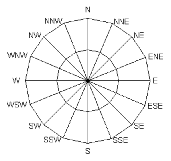
Wind cardinal and degree directions correlation
Wind direction is reported as an orientation from where the wind is blowing. The
directions of the wind is determined at the geographical system of coordinates
and could be represented in degrees and cardinals terms.
wind direction in degrees -azimuth degrees, i.e., in a numerical measure that
moves around the Rose of the Winds in a clockwise circle from 0 degrees (N) to
360 degrees (N).Wind direction in cardinals - direction based on are the four
main compass directions: north, south, east, and west. Relative to north, the
directions east, south, and west are at 90 degree intervals in the clockwise
direction.
Please find below the table with correlations between cardinal
and degree wind directions:
| Cardinal Direction | Degree Direction |
|---|---|
| N | 348.75-11.25 |
| NNE | 11.25-33.75 |
| NE | 33.75-56.25 |
| ENE | 56.25-78.75 |
| E | 78.75-101.25 |
| ESE | 101.25-123.75 |
| SE | 123.75-146.25 |
| SSE | 146.25-168.75 |
| S | 168.75-191.25 |
| SSW | 191.25-213.75 |
| SW | 213.75-236.25 |
| WSW | 236.25-258.75 |
| W | 258.75-281.25 |
| WNW | 281.25-303.75 |
| NW | 303.75-326.25 |
| NNW | 326.25-348.75 |
API errors
API calls return an error 400000
You can get the 400000 error when you request data for a period not covered by your subscription. Access to specific time ranges in each product depends on your subscription level. If you need access to data beyond the permitted range, consider upgrading your plan.
API calls return an error 401
You can get the error 401 in the following cases:
- You did not specify your API key in API request.
- Your API key is not activated yet. Within the next couple of hours, it will be activated and ready to use.
- You are using wrong API key in API request. Please, check your right API key in personal account.
- You are using a Free subscription and try requesting data available in other subscriptions . For example, 16 days/daily forecast API, any historical weather data, Weather maps 2.0, etc). Please, check your subscription in your personal account.
API calls return an error 404
You can get this error when you specified the wrong city name, ZIP-code or city ID. For your reference, this list contains City name, City ID, Geographical coordinates of the city (lon, lat), Zoom, etc.
You can also get the error 404 if the format of your API request is incorrect. In this case, please review it and check for any mistakes. To see examples of correct API requests, please visit the Documentation of a specific API and read the examples of API calls there.
API calls return an error 429
You will get the error 429 if you are a user of a Free subscription and make more than 60 API calls per minute (surpassing the limit of your subscription).
Please consider upgrading to a subscription plan that meets your needs or reduce the number of API calls in accordance with the limits.
API calls return errors 500, 502, 503 or 504
In case you receive one of the following errors 500, 502, 503 or 504 please contact us for assistance. Please enclose an example of your API request that receives this error into your email to let us analyze it and find a solution for you promptly.